

Point Roberts: Why the United States owns this small peninsula off Canada
Point Roberts: Why the United States owns this small peninsula off Canada
Point Roberts feels like it should be part of Canada, but it's not!

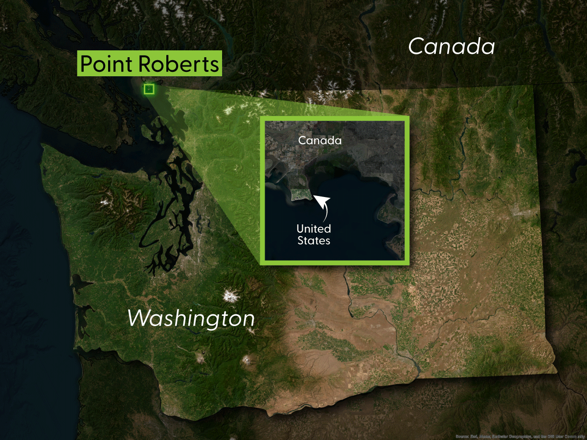
Have you ever noticed this small peninsula of Washington state? Chances are, unless you live in Washington state or British Columbia, you haven’t. That’s because it’s incredibly small and, unless you knew otherwise, you’d largely expect that this piece of land would actually belong to Canada. After all, despite it being slightly below the 49th Parallel, the dividing line for much of the U.S. and Canada, it’s actually directly connected to Canada, not the U.S. As it turns out, this little nugget of land has an interesting geographic history attached to it.
History of Point Roberts and Oregon Country
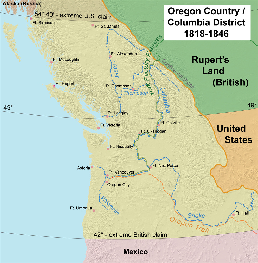
To talk about Point Roberts is really to talk about Oregon Country at large. Oregon Country was broadly the region that today would include Idaho, Oregon, Washington state, and British Columbia. And, between 1818 and 1846, it existed as a sort of “no-man’s land” wherein both the United States and Great Britain laid claim to the entire region. But while laying claim is all well and good, neither really had the ability or power to actually project their influence on the sparsely populated region. At this time, native tribes still largely roamed without much interference.
And so the Oregon Country was born (also known as the Columbia District to the British)! Because neither country could really enforce its borders in the area, the two opted instead to sign the Treaty of 1818 which established the entire region as being jointly controlled by both countries. This meant that people could still claim land and, generally, trade was allowed to be carried out under both country’s respective laws.
While this kind of structure worked well enough in 1818, as people moved to the region, it got a little more complicated. As it turns out, following and attempting to carry out two country’s laws is rather complicated. This all effectively came to a head when, in 1843 a large band of settlers from the United States made their way to Oregon, an effort that was intentional by the U.S. government in order to tip the population balance well in their favor and secure the land for themselves by right of population and citizenry. A similar effort by British-Canadians proved to be too little, too late. The area was relatively swarming with Americans.
With so many Americans now in the general region, the U.S. Congress effectively repealed the Treaty of 1818, ending their support for a jointly controlled region. While outright war over the territory was probably never likely, due to, once again, the logistics of getting to the region, neither side really wanted to give up the entire territory. And so a compromise was made! The Treaty of Oregon determined that everything north of the 49th parallel would be a part of the British Empire and everything south of the 49th parallel would be a part of the United States, with one exception: Vancouver Island. Given that Fort Victoria was seen as a very valuable trading colony at the time, Great Britain insisted that the island remain with them and added language to the treaty that said the 49th parallel would only extend as far as to the ocean, thereby allowing for Great Britain to keep control of Vancouver Island.
What about Point Roberts?

As it turns out, map making and determining the exact impacts of such a hard boundary was quite complicated in 1846! While the British effectively secured Vancouver Island for themselves, they didn’t really account for any wayward peninsula that might exist. And one did exist: Point Roberts!
According to historic reports: upon completing the survey of the land, it was determined that Point Roberts was, in fact, below the 49th Parallel and, therefor would be a part of the United States unless it was negotiated out. And Britain did attempt to have it transferred back to them. According to one report, Great Britain went so far as to make an official offer to give an equivalent piece of land elsewhere in exchange for keeping Point Roberts, but the United States never responded — or at least there’s no record of it. Regardless, Point Roberts stayed with the United States and the rest is history.
Today, Point Roberts maintains as a small island of sorts with approximately 1,100 residents. During the COVID-19 pandemic, when the border between the United States and Canada was effectively shut for a couple of years, the Port of Bellingham had to set up a temporary ferry service to bring people to and from the peninsula. That ferry stopped service in August of 2021, the same month that the border was re-opened.
And that’s the weird little history behind this, mostly unknown little peninsula. Should Point Roberts belong to Canada? Probably, if things has been rectified back in the 1800s. But today, it’s likely not going to change hands, though there was an attempt to secede the territory back to Canada back in the middle of the 1900s. Still an interesting piece of Pacific Northwest history though!
While some locals may have mixed feelings about this, I think the way out of this predicament is pretty obvious. On the east coast, there's a comparable situation of a Canadian island only accessible from a bridge to the U.S. - Campobello Island. They should simply be traded between the nations, whereby also giving all residents a passport both country until their deaths (which is under 2,000 people).
The Northwest Angle is trickier and should likely just be purchased by Canada if it can get American buy-in. There's only 54 people to convince, well, and the Minnesota and U.S. governments.